Legend
Tonquin Project
PGE is working toward Oregon’s clean energy future -building a smarter, stronger, and more flexible grid to deliver customers the most cost-effective, reliable power today and into the future. Customers rely on energy to power more of their lives than ever before. PGE is upgrading its infrastructure to bring on more diverse types of energy and to accommodate the many new ways we’re using it. These upgrades will support growth – in population, economic opportunity, and reliance on electricity to power our lives.
The Tonquin project upgrades 11 miles of 115kV transmission lines and adds a new substation in the southern portion of PGE’s service area. These improvements will support load growth and improve reliability for the entire region.
This multi-year, multi-segment construction project is scheduled to begin in the summer of 2023 and will be completed by the end of 2025.
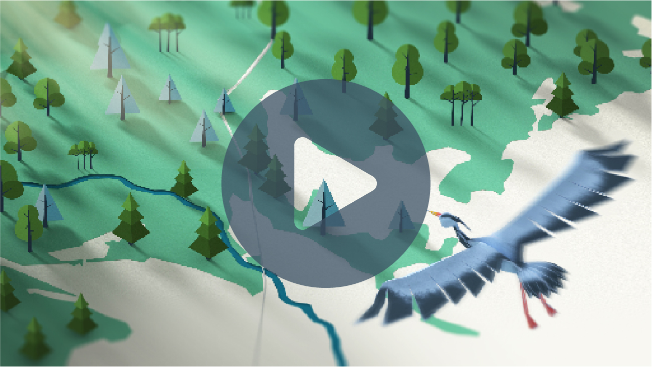
To learn more detail about the project, click on the video and review the interactive map illustrating the project components. Note that visual simulations are approximations for illustrative purposes only. Final engineering and construction details may change pending public, regulatory and utility review.
Timeline
Overall Project Time
Meridian-Sherwood Loop
Rosemont-Wilsonville
Sherwood-Wilsonville
McLoughlin-Tonquin
Tonquin Substation Construction
Schedule and scope is subject to change pending review.
Proposed Tonquin Substation
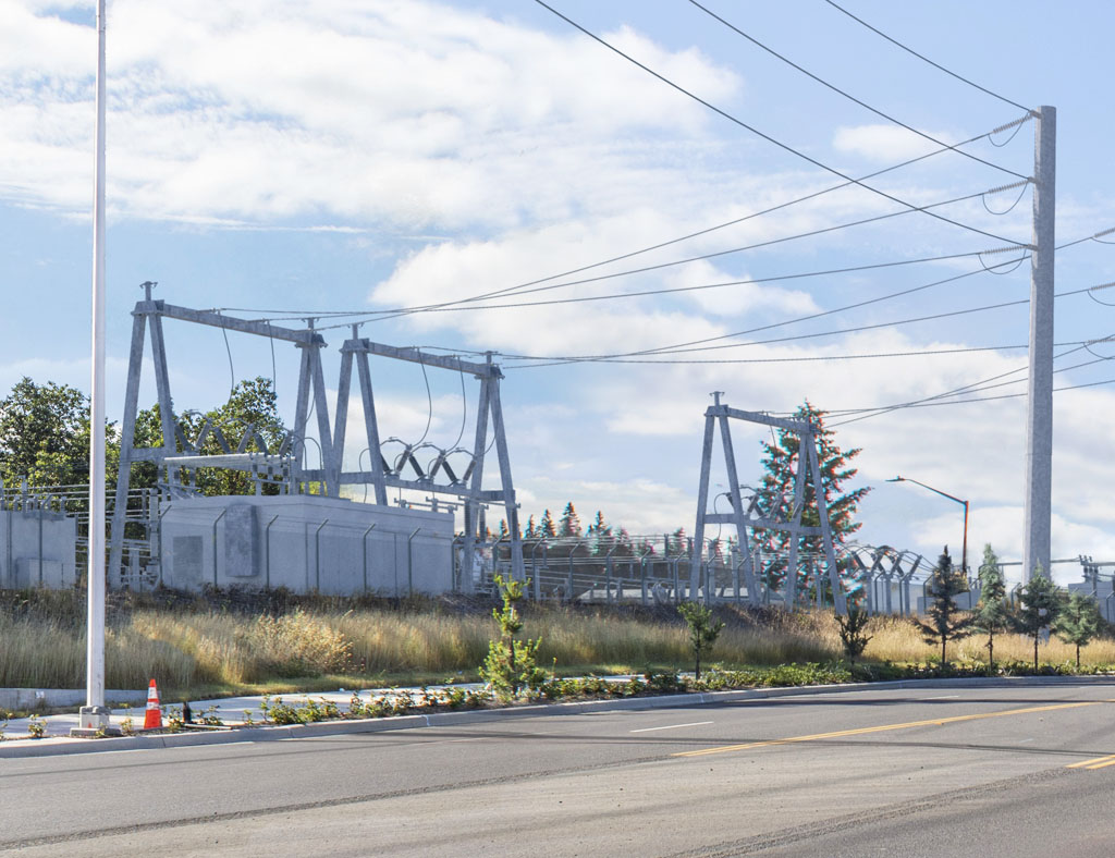
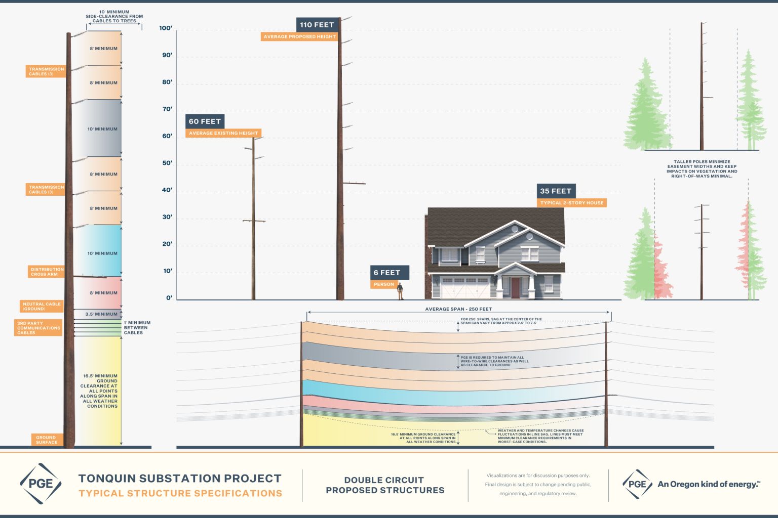
Substations serve as electrical intersections that reduce the voltage and act as a distribution and switching system to the homes and businesses they serve. PGE’s proposed Tonquin substation is a first step in meeting increased growth in the Sherwood, Tualatin, and surrounding areas and improving power reliability throughout the region. It will provide relief to two nearby substations nearing their electric load capacity. Site preparation began in summer 2023. Construction will be completed in spring 2024. The site for the proposed substation is located on PGE property in the City of Tualatin.
Photo Simulations
These photo simulations help provide an accurate and realistic depiction of a planned project. They use photography and detailed 3D renderings to create ‘before and after’ simulations of the project at different locations. Simulations consider the width of the right of way, vegetation management requirements, environmental considerations, visual impacts, and material finishes to help illustrate how the proposed project may look when it is built. Note that photo simulations are approximations for illustrative purposes and to facilitate discussion. Final engineering and construction details may change pending public, regulatory, and utility review.
There are two ways to use this tool:
- On the overview map, click the photo simulation icon at any of the locations. Click ‘view simulation’ on the photo that pops up. Click and drag the slider to see the transition between existing and proposed conditions.
- In the project segments, click the photo simulation of interest. Click and drag the slider to see the transition between existing and proposed conditions.
Information Resources
To further your understanding of the project, view or download project videos, documents, and frequently asked questions.
Related Videos

Overhead Power Line Construction
01:35
Power Lines, Trees, and Vegetation
02:18
Topic Video 1
00:00
Important Documents
Meridian - Sherwood Loop
Rosemont - Wilsonville
Sherwood - Wilsonville
- Coming Soon
McLoughlin - Tonquin
- Coming Soon
Tonquin Substation
Frequently Asked Questions
The Tonquin Project will add a new substation and upgrades to 11 miles of 115 kV transmission lines in Tualatin, Sherwood, Stafford,
Wilsonville and unincorporated Clackamas County. These improvements will strengthen the grid, making it more resilient and reliable while adding capacity to meet future needs. Added flexibility will enable energy to flow from different substations, reducing power outages and enhancing system redundancy.
No. Clackamas County is widening the road north of the Tualatin River from Pattulo Way to Rosemont. More information is available at https://www.clackamas.us/engineering/st-rd-improvements/
Substations serve as electrical intersections that reduce power voltage and act as distribution and switching systems to homes and
businesses. The Tonquin substation will help meet increased growth in Sherwood, Tualatin and surrounding areas. It will also provide relief
to two nearby substations that are nearing their electric load capacity, improving the reliability of power for the surrounding area and
region.
The Memorial Substation will be located on PGE property in Wilsonville. It is a distribution substation that will receive electricity from the existing transmission line along SW Boones Ferry Road through two new line crossings over Interstate 5. This new substation will connect to the existing distribution infrastructure that is already underground, to support growing electrical demand in Wilsonville to increase capacity and ensure reliable service.
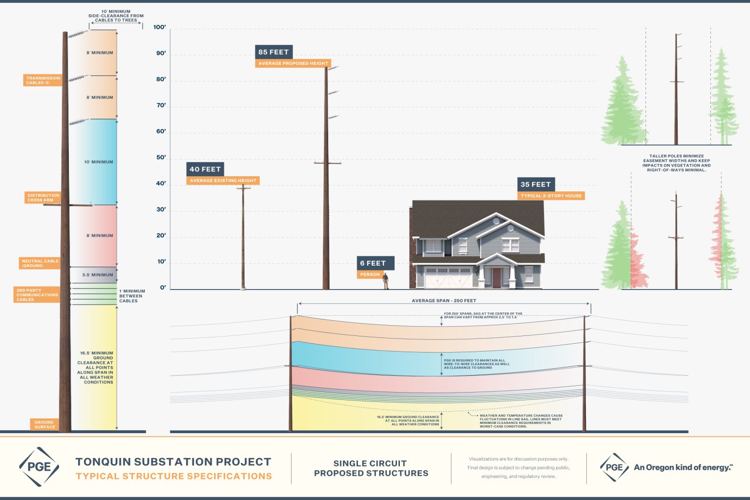
The existing 7.4 miles of power lines along SW Stafford Road are being upgraded from distribution power lines to distribution and
transmission lines. The current poles will be upgraded to support three transmission cables at the top, three distribution lines in the middle and non-PGE utility lines (typically for phones, internet, etc.) at the bottom. PGE is required to lease our towers and poles to utilities. Taller poles are required to accommodate the additional lines and maintain required clearances.
For transmission, PGE is required to meet mandatory reliability standards and planning requirements set by federal regulators and regional coordinators, which includes an obligation to collaboratively plan with Bonneville Power Administration and others. To meet these standards, planning requirements and directives, PGE regularly assesses system performance to determine where improvements are needed to meet customer needs reliably. This assessment and planning encompass PGE’s system, our interaction with BPA’s system and regional systems to help bring electricity from different locations and generation resources, like solar or wind, into PGE’s service area. They also help make sure that our systems function as planned in an interconnected electric grid.
When upgrades are needed, we begin a multi-phase planning process involving different engineering and project teams with different areas
of expertise. At a high level, these teams evaluate potential pathways for electricity to flow reliably from generation resources through the
grid to customers; examine existing infrastructure and options for physical routes that will deliver electrons where they’re needed; and plan and design lines and substations factoring a wide range of variables that include right of way, terrain, permitting needs, construction constraints – including limits on where PGE can place lines, competing infrastructure, and more.
The Tonquin Project evolved from PGE’s local transmission planning process, which considered a range of factors including PGE’s right of
way access along existing distribution lines. This pathway is the least costly way to deliver energy reliably to where it is needed. When PGE
invests in equipment upgrades, the Oregon Public Utility Commission will review those expenditures to determine if they were reasonable
and prudent, because they result in price increases to all customers.
PGE cannot provide definitive information about how the addition of 115 kV transmission lines may impact property values as part of this
upgrade to the existing 7.4 miles of distribution power lines along SW Stafford Road. The vast majority of poles are within the public right of
way and will generally remain within five feet of their current locations. The transmission wires will appear fine and dull, helping them to
blend into the background. Some poles will remain wood, and some will be upgraded from wood to either galvanized or weathering steel,
typically in areas where the line has more curves. PGE’s team will always work with landowners to find a suitable replacement for any
impacted trees, shrubs and plans, as we try to restore the property to its original condition or better.
There are a number of tradeoffs when it comes to installing 115 kV transmission lines underground. While every project is unique, with
undergrounding, the most significant tradeoff is cost – which is in the order of 10x more expensive than installing overhead lines. When PGE
invests in equipment upgrades, the Oregon Public Utility Commission will review those expenditures to determine if they were reasonable
and prudent because they result in price increases to all PGE customers. For this project, PGE is working within existing public right of way. To underground, PGE would want a dedicated easement to protect underground facilities along this corridor in order to protect customers from the prospect of paying for the lines to be buried, and then potentially paying to relocate them should future public works projects so require.
Some of the tradeoffs when it comes to undergrounding transmission lines are:
- The need for more easements. Undergrounding transmission lines usually involves burying large vaults at regular intervals, in
addition to the cables and conduits. - More vegetation removal. To prevent roots from intruding into the electrical conduits in a transmission corridor, limited vegetation
is allowed to grow above the lines and in the surrounding area. - Longer construction times, more heavy equipment and impacts to vegetation and roads.
- More extensive maintenance inspections. Underground transmission lines can require patrolling to assess changes in soil depth,
cover type, vegetation and other variables that can impact the ability of the line to effectively dissipate heat. They are more
susceptible to water ingress, which can lead to equipment degradation and faults that in turn require more significant repairs. - Lengthier problem-solving and repair process. If lines are damaged or experience a fault, the process of identifying the issue,
accessing it and repairing it requires more time, resources and heavy equipment, leading to longer outages. - Supply chain challenges. The cables and hardware used for underground transmission are often designed based on the unique
soil and operating conditions, which can affect their availability for installation and repairs.
No. The transmission wires will appear fine and dull, helping them to blend into the background.
Some poles will remain wood, and some will be upgraded from wood to either galvanized or weathering steel, typically in areas where the
line has more curves. More than 20 photo simulations of the Rosemont – Wilsonville segment are available under the Photo Simulations tab to provide a look at the current and proposed changes.
PGE standards meet or exceed standards set by the National Electrical Safety Code (NESC), which IEEE keeps up to date with industry and technology changes. The NESC establishes ground rules and guidelines for practical safeguarding of the public and utility workers during the installation, operation and maintenance of electric supply and associated equipment. PGE and contractor engineers are seasoned professionals with experience designing structures to PGE standards and NESC requirements. All PGE design documents are stamped by a professional engineer registered in the state of Oregon.
Because safety is a top priority, PGE conducts annual patrols to visually inspect structures, insulators, hardware, conductors and static wire. If PGE identifies any issues, we perform the work necessary to maintain compliance with NESC standards. Every ten years, PGE inspects utility poles that support overhead equipment to assess pole condition. Depending on the pole’s condition, PGE will either apply remedial preservatives to help maintain pole condition, or we will replace the pole.
An informational video about how overhead power lines are constructed is available under the Resources tab.
Over the years, public concern has arisen about the research on electric and magnetic fields (EMF) in everyday life. Scientists have been researching potential health effects from EMF exposure since the 1960s. Multidisciplinary review studies have consistently concluded that there is insufficient evidence to establish causality between EMF and adverse human health hazards. Because of the lack of evidence, no “safe” or “unsafe” levels of exposure to EMF have been established by the government or health organizations.
Safety is a main focus at PGE, and we appreciate concerns about EMF around power lines. We work to address those concerns by employing EMF industry best practices in siting power facilities; keeping informed on the latest research from universities, federal and state health agencies, industry-sponsored programs and international health organizations.
More information is available in an EMF Fact Sheet posted under the ‘Resources’ tab.
A public right of way is a right of way that has been dedicated to the public for use, that is controlled by either a local, state or federal entity. Utilities that are located in a public right of way get approval from the controlling entity to locate the utility in that public right of way. Overhead lines, poles and other equipment can be located within this right of way. If the utility needs to be located on private property, it will typically be covered by an easement, which is a perpetual agreement that gives PGE the right to access and work on lines and equipment. This provides a safe and documented path from our generation sites to homes and businesses.
The vast majority of poles are in the public right of way and will generally remain within five feet of their current locations. PGE is meeting with every landowner where an easement may be involved to discuss the project. We bring a collaborative mindset to those conversations, which are unique to every landowner and property. We listen to concerns about what poles or other equipment might look like and whenever possible and may move a pole (within certain limits) to address the landowner’s concerns.
Because of the upgrades, PGE’s footprint on a particular property may change. In those instances, PGE seeks an easement to compensate an impacted property owner and document any encumbrances on their property. When we seek easements, we share with a landowner the factors that inform the compensation amount offered. The easements involved on SW Stafford Road are largely because of aerial and vegetation impacts.
- Aerial impacts will occur on a small number of properties where PGE lines or cross-arms may cross over the property. The remaining easements for aerial impacts are being offered because a line could cross a property in certain conditions, for example, exceptionally high winds exceeding 75 MPH could cause the line to blow out over the property.
- PGE is seeking easements to address vegetation on private property that could interfere with its equipment. The easement will allow PGE to remove vegetation that does not meet PGE’s required clearances or is at risk of growing into the line. PGE maintains clearances for safety, to help reduce the risk of outages and potential for vegetation to contact our lines and equipment. PGE will work with the property owner on appropriate landscape options that will not cause clearance issues.
PGE has not commenced any condemnation actions as part of the Tonquin Project. PGE’s goal is to work collaboratively with property
owners to resolve concerns. Most poles are within the public right of way and will generally remain within five feet of their current locations.
The easements involved on SW Stafford Road are largely aerial and vegetation easements and should have limited impact to properties.
PGE is meeting with every landowner where an easement may be involved to discuss the project. Because PGE has not commenced any
condemnation action, PGE has not sought a Certificate of Public Convenience and Necessity (CPCN) from the Public Utility Commission of Oregon.
During project planning, PGE environmental personnel work with project teams to assess potential impacts to wildlife and habitat
resources. Considerations include site-specific factors such as local wildlife species and habitat, local land use, topography, line and equipment configuration, and other project details. PGE biologists have reviewed available internal, state, and federal data on wildlife and habitat in the project vicinity and the possible impacts of this project. Overall, the area is low-risk for sensitive species and habitats. The proposed project follows existing roadway and utility corridors which further minimizes impacts to avian and wildlife species and habitat. Additional measures around vegetation removal will be implemented to further reduce any potential impacts. PGE documents and monitors any reports related to bird and wildlife impacts from our facilities.
PGE has an Avian Protection Plan which implements several measures used to evaluate and reduce risks to avian species while increasing system reliability. Key measures include training employees on bird protection issues and procedures; tracking bird and nest issues to assist in minimizing impacts; building nest platforms to reduce pole-top nesting and outages; implementing design features to poles and transformers that reduce bird risk; and, collaborating with the U.S. Fish & Wildlife Service and the Avian Power Line Interaction Committee on strategies that reduce bird and power interactions.
When we plan new infrastructure construction or a major upgrade, we consider a range of variables so power lines have a safe path from
where power is generated to the homes and businesses they serve. As a rule of thumb, the right of way under distribution power lines must
be clear of trees. Trees inside the right of way should not be taller than 20-30 feet when fully mature. Trees around high-voltage transmission lines should not exceed 20 feet in height when fully mature, and they should be at least 30 feet away from our equipment. Sometimes, PGE will need to remove a tree before it becomes a hazard to power lines, if it’s encroaching in our learance area, or showing signs of damage or disease. We make those determinations with the help of certified arborists and forestry staff. In those instances, we reach out to tree owners to discuss tree removal and potential replacement.
PGE’s team will always work with landowners to find a suitable replacement for any impacted trees, shrubs and plants. PGE tries to restore the property to its original condition or better. There are limitations in some instances, for example, if large trees are within the easement area. In those instances, PGE will work with the landowner to find a suitable alternative that meets clearance requirements and doesn’t impede access to the lines for inspection, maintenance and repairs.
An informational video on Power Lines, Trees and Vegetation is available under the Resources tab.
Permits to remove trees from this portion of the project are largely ‘Right of Way’ use permits. All required permits are posted under the ‘Resources’ tab.
As part of our ongoing evaluation of High Fire Risk Zones, we’ve identified 10 areas within PGE’s service area that scientific data and risk modeling using thousands of data points, variables and scenarios have identified as being at higher wildfire risk. The Tonquin Project is not within these 10 areas. Even still, the safety of our customers and community is always a top concern. It’s important to know that PGE stands ready to turn off power for public safety in the areas beyond our higher wildfire risk areas.
When it comes to wildfire, there is no single solution to protect power lines from the effects of climate change. Our year-round efforts and
2023 Wildfire Mitigation Plan are rooted in protecting people, property and natural environments. Our strategy is informed by ongoing system assessments and data-driven risk analysis, and includes year-round prevention work, such as using enhanced designs based on industry best practices, upgrading equipment and expanding tree-trimming and vegetation management in high-risk areas.
PGE’s 2023 Wildfire Mitigation Plan identifies a holistic strategy to mitigate wildfire risk through ongoing system hardening, advances in situational awareness tools and assets, perational changes and vegetation anagement. For example, PGE is using high-definition cameras with artificial intelligence that allows local public safety agencies to respond quickly to fire through real-time detection and
triangulation. PGE vegetation crews also routinely inspect trees and vegetation around our power lines in order to maintain necessary
clearances and reduce the likelihood of trees or debris making contact with our lines.
PGE has prescribed standards for the clearance of vegetation located under, near and around our overhead and underground infrastructure
near our poles on a site-specific and construction-specific basis. Additionally, PGE subscribes to the principles of Integrated Vegetation Management (IVM) in the right of way. This promotes the retention of desirable vegetation species as a means of biological control, which helps in response to climate change and fuel loading.
Other IVM methods may include a combination of chemical, cultural, mechanical, and/or manual treatments. PGE’s FITNES program
identifies vegetation within proximity to certain types of assets (expulsion fuse, etc.) and prescribes treatment to the site as needed to maintain necessary clearances.
PGE has no current plans to underground transmission lines as part of our wildfire mitigation efforts. All undergrounding is of distribution lines.
Annually PGE assesses High Fire Risk Zones using wildfire risk modeling. Changes are certainly possible as we continue to learn more about climate change and its impacts, and adapt accordingly.
Certificate of Public Convenience & Necessity
On April 17, 2024, PGE filed a petition for a Certificate of Public Convenience and Necessity (CPCN). The petition initiates a public process that includes review of documentation, an investigation by the PUC and public testimony. For more information, visit the Oregon Public Utility Commission’s FAQ.
What will the project look like?
Use the map above to explore the project and see detailed information about the proposed structures. Click the structure location dots to display specific information including proposed structure height and type. The image below is to help illustrate the project elements, although final engineering and construction details may change pending public, regulatory and utility review.
Welcome to GeoVoice
GeoVoice is an interactive map tool for transmission line projects. You can use GeoVoice to explore and comment on proposed projects and participate firsthand in the process. To use GeoVoice, follow the instructions below.
If you’d rather contact PGE to share a comment, click the Contact Us link below.
GeoVoice Help
- Sign Up
- Click Submit a Comment
- Drop a pin
- Provide information about the nature of your comment
- Add any important details
- Click Submit